|
Meet Director: Kathy Bullard
Course Setter: Joe Sackett
Schedule:
| 7:30 a.m. |
|
Registration & Maps for 6 hour team event |
| 9 a.m. |
|
Briefing & Start for 6 hour team event |
| 10:30 a.m. |
|
Registration & Maps for 3 hour individual event |
| Noon |
|
Briefing & Start for 3 hour individual event |
| 3 p.m. |
|
Course Closes -- you must be back by 3 p.m. !! |
| 3 p.m. |
|
Control Pickup |
Snowgaine! Cost:
$15 per person pre-registered
$20 day-of event
Sorry, on-line registration is now closed. While we won't have a pre-printed map ready for you, please let us know that you will be attending so that we can sufficient supplies.
|  |
View Larger Map
|
Details:
CAOC's 9th annual Snowgaine will offer everything you expect and more. Of course you will experience crisp, clean, cold air as you travel through the frozen forest and atop majestic bluffs overlooking the Mississippi river. Yes, there will be snow, just how much I do not know. But this year we have two major new additions to our event, a new map and a solo category.
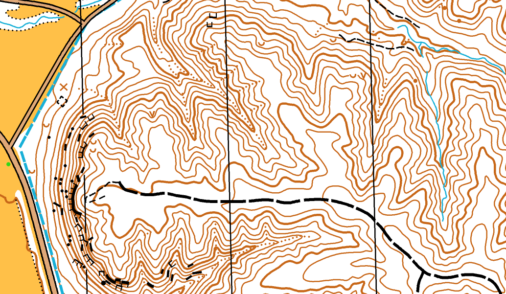
The new map is incredible and it alone will make the trip worthwhile. Every spur and reentrant is now shown and there are hundreds of them. This accuracy comes with a price; success will depend on keeping map contact while making smart route choices. Are you ready?
If you want a further challenge, you may now compete in the individual category. While the time limit is 3 hours, this race will be intense. More controls will be set so that careful route planning will be a major factor in maximizing your score. For safety reasons, only advanced orienteers will be allowed to go solo.
As always, there will be a 6 hour team category. While some teams were able to "sweep the course" in past years, such a feat will be very difficult this year.
We invite all midwest orienteers and adventure racers to share the beauty of frozen nature and the challenge of the Snowgaine!
Course Setter's Notes:
This is a "score-o" type event where you are given a specified amount of time to visit controls in any order that you choose. Each control has a point value associated with it. Your final score will be the sum of all the points you accumulate for visiting the controls. We will use regular pin punching (not e-punch). Score ties are resolved by finish order.
There will be a lot of controls this year. They will be placed in advanced locations due to the improved accuracy and capabilities of the map. Most controls will be in located on contour features (especially in small reentrants). Expect to use your advanced orienteering skills in addition to your endurance.
Control quantities, proximity & score value are carefully calculated to provide good options for selecting control order. Competitors in the 3 hour individual category should be especially careful planning their route before the start. Since a sweep is impossible in the solo event and unlikely in the team event, the winner may be determined by selecting an efficient order of controls. Plan smart.
Equipment Notes:
Bring a cell phone. Reception is spotty but works in much of the park. This small additional weight is worth the extra measure of safety.
There will be water at the start/finish and some on the course too. Bring a camelback with a large bladder as dehydration can be a problem in winter. Bring food, 3-6 hours is too long to go without replenshing your energy stores. Of course we will serve hot food at the start/finish location both during and after the race.
Based on a recent trip, the snow is not deep but (of course) that could change quickly. Boots & wool socks with snow-gaiters are recommended. Heavy trail shoes might be an option for those who know their equipment and have winter running experience. Do not use waterproof socks as your sweat can not escape and may freeze, causing frostbite.
Dress for the weather. Wear layers of technical fabrics, silk or wool and a shell if it is windy or precipitating. Do not wear cotton. Chemical hand warmer packs work very well in gloves. Beware of overdressing too as climbing the many steep hills will generate a lot of heat.
The above are only suggestions. This is rough terrain in a winter climate. You should make informed choices about equipment based on your own experience or other expert advice.
Map Sample:
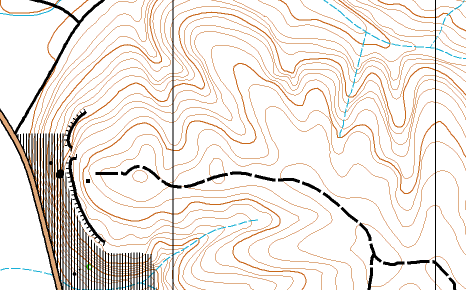
Old Map:
Mapper's Notes:
You will be running on an enhanced basemap. It is a massive improvement over our old map. The contour lines were generated from accurate LIDAR data and are completely reliable. There are other features placed on the map from inferring their signature in the LIDAR data. As the map has not been fieldchecked, there are some unmapped & mismapped features out there. You may be briefly confused to see something but not find it on the map or see it mapped differently. In these cases, navigate by contours as you probably should anyway.
Here is a list of features and their reliability:
Contours - very accurate (spurs, reentrants, etc.)
Trails - very accurate.
Fields/clearings - very accurate.
Cliffs - those on map are mostly accurate, few unmapped.
Boulders - those on map are mostly accurate, some unmapped.
Dot knolls - those on map are mostly accurate, some unmapped.
Ditches - those on map are mostly accurate, hard to see under snow.
Rootstocks - none on map, not a lot of big rootstocks at Palisades.
Vegetation - all woods mapped white, despite some deadfall & undergrowth.
Directions
Some general directions follow. Better yet, look on a map and use
your orienteering skills!!
From Chicago: Take I-90 to Hwy 20 in Rockford.
Follow Hwy 20 west to Hwy 76 and turn south. Take Hwy 76 to Hwy
64 and go west to Savanna. Hwy 64 joins Hwy 84 and passes through
Savanna. Approximately 2 miles past Savanna is the main entrance
to the park. Enter and park at the Ranger house to the right.
From the Quad Cities: Take I-80 to IL Hwy 84 and
take it north to Savanna. Approximately 2 miles past Savanna is
the main entrance to the park. Enter and park at the Ranger house
to the right.
From St. Louis: Get to the Quad cities and take
I-80 to IL Hwy 84 and take it north to Savanna. Approximately 2
miles past Savanna is the main entrance to the park. Enter and park
at the Ranger house to the right.
From the North: Get to Galena and take Hwy 20
South/east to Hwy 84. Take 84 south approximately 15.5miles (through
Hanover) to the park entrance.
|