|
Here are the results:
Green Results & Splits...
Green Extended Splits...
Red Results & Splits...
Red Extended Splits...
There were a lot of competitors on the green course and solid performances throughout the field.
Top honors on green goes to orienteering journeyman Kevin Teschendorf for his blazing run. Anna Cunningham's stellar performance and excellent run by Oliver Clot round out the top three.
On the red course, Norwegian veteran Audun Botterud ran clean and fast away from the field to the top. Only six minutes separated the next four: Joe, Natalia, Valentas and Jim.
============================
Course Review
Maricel worked very hard to set some challenging and fun courses for us through some difficult terrain. Some of us (myself included) were pushed to the limits of our navigation skills. This review will go over the legs on the red and green courses and suggest possible approaches. Bear in mind that I am but a dilletante and still fairly new to orienteering but have studied the sport and also learned some painful lessons.
So, let's break down the green course...
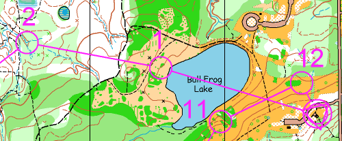
#1) It's very different not to see your map/course before the clock starts but it's really good practice to plan "under way." Use the easy trail run to 1 to plan as much as possible. Are you going to follow the edge of the lake until you see the big thicket or maybe hook right onto the smaller trail to avoid the rough ground? It's up to you. While running to 1, I planned my route to both 1 and 2.
#2) My plan to 2 was to head straight there until I got into the woods and then bear left to pick-up the stream as a handrail. It was a good plan but it required a hop from the end of the first stream to one of the other two that joined at the control. I did not properly execute this last part.
#3) Route choice time. Did anyone hook way right into the clearing and up the trail/road? Good for you, I think it's a good choice, although I didn't. There is also a series of trails to the left that look reasonably promising. I chose to go straightish through the white and light green and check-off on the many features along the way. I executed this well but the wet summer made the foliage much thicker than mapped and thus slower (I think) than the other options.
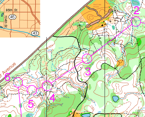
#4) 4, 5 & 6 were different on the red course but 4 looks like a trail until the third big reentrant and then 50m along the top of the bank.
#5) A little choice here.
#6) A deceptively hard control (I think) with only subtle contours or a lucky compass heading to guide you. Through painful experience on legs like this, I learned that I relied on my compass too much. I now use the map more and would take this carefully because a good course setter will force you to find the feature before the control flag. I suggest locating the reentrant/stream along the left and walk north of it looking for a depression (not the control). If you come to the stream bend, know that you've gone past it but now you're at a nearby attack point.
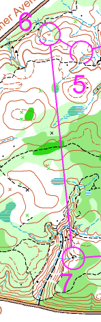 |
#7) I did not have this leg but the first thing that I see is a lot of green to the left (east) that I want to avoid by going to the right. So how would I reliably navigate this way? Contours. Climb SSW to the top of the hill, head due S and move to the right whenever I hit thick stuff. After crossing the trail, head SSE along the high ground and hopefully (my navigtion still involves hope) bullseye the middle of this awesome feature on a compass heading. Yes, I said compass heading, there is a time and a place for them and even with the inevitable error it's hard to miss this "gorge." I would key on the big spur around which the main trail bends, it was easy to find on my course. Follow the trail south for 100m from the spur and look for the big reentrant on my left and confidently climb it.
|
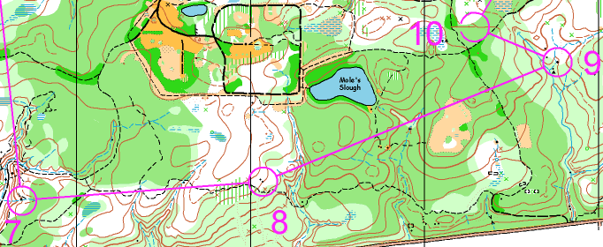
#8) We had these small bolders on our course but from a different direction. The hard problem out there is where to leave the trail. I see contours, changing foliage and a subtle trail bend to guide you. Admittedly, this is not much but you're on an advanced course. I would observe the "slash" foliage as the trail was moving level along the hillside. When the trail started to turn downhill (and hopefully the foliage changes) I would carefully move toward the bolders knowing that the reentrant would serve as my backstop.
#9) This was one of my favorite legs on my course because of the not-so-obvious (to me) route choice. Did you see it? Congratulations if you took it because the trail near 8 is very seductive but provides a very hilly route to the control. The less apparent but certainly best route is NNE to the trails around Mole's Slough. Route choice legs are a sign of good course design and make sure that you look for them before you head off to any control. They are typically found on the longer legs.
#10) Not on my course but looks tough. I would key on foliage changes and if all else fails, attack from the trail intersetion to the south.
Many legs were the same on the red course and there are a few additional interesting ones.
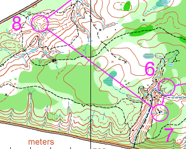
#8) I think the first goal is to get yourself to the trail while avoiding the green stuff. I headed NW and checked-off on the swamp along the way so I knew where I would be when I hit the trail. I made some mistakes in the last half of this leg, but certainly the best route is to follow the slope down and then along the north side of the big e/w reentrant right into the control.
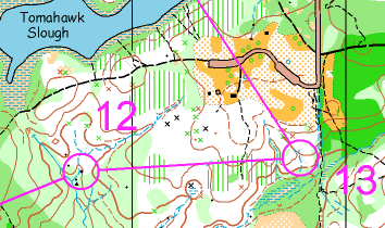
#13) While straight is an option that I considered, I thought this might leave me uncertain exactly where I hit the reentrant 50m from the control. I opted for the more conservative route slightly left until the clearing was visible through the trees and then east across the first reentrant and down the slope (keeping the reentrant 50m on my right as a handrail) into the control.
If you've taken the time to read this hobbyist's long discussion, I think this last control is a perfect example of a point I always try to make. Orienteers have different strengths, weaknesses and take different enjoyment from the sport and will therefore navigate differently. While many competitors chose the straight and fast route on #13 above, I was racing and knew I was tired so I decided to give-up seconds to insure against the loss of more time. Orienteer at whatever speed and navigate how ever it suits your goals and enjoyment.
Oh yeah, and another thing that I've learned from others and firmly believe. If you did not meet the orienteering goals that you set for yourself (whatever they were) or had some bad legs (as I did), it is very easy to remember and focus on what went wrong. Even if you take a constructive approach toward improving this "bad stuff" MAKE SURE YOU also reinforce the "good stuff" that you did. If your goal is to improve, you must improve what didn't work AND repeat what did work for you.
- The O-Dilletant
|