|
Many folks joined us for a beautiful day of orienteering through the spring thaw.
Jeff Shaw did an excellent job in his debut as course setter.
Not only were the courses well planned but we all got some bonus distance
added thanks to an OCAD glitch. If you were thought you were taking
longer than you should, it wasn't your pace, your course was 50% longer than
marked. I hope this makes you feel good now that you are done.
This meet was made possible thanks to the fantastic staff at the DuPage Forest
Preserve. Thanks Tex & all.
We wouldn't have been able to handle the big attendance without the major help
from the volunteers. Huge Thanks to Michael for the preprinted maps,
Chris, Marianela & Viktor at registration, Charlie at parking,
Jim, Peter, Audun, Porter, Jim & Krista at timing and
Jennifer, Kathryn, Tracy, Milan, Audun & Maricel fetching controls.
Jeff Shaw deserves another mention for the yeoman's effort it took to set all of the
controls and water by himself.
View the White, Yellow & Orange Results...
Lenny & Valentina navigated to the top of the green course. Peter and Krista
went to a photo-finish for second place. Great runs all !!
Here are the green course results:
Green Results and Splits...
Green Extended Splits...
Today's competition level on red might be a harbinger of a great season. Maricel
remains at the top but Audun and newcomer Oivind were dangerously close to his
heels. Excellent runs guys, your international experience raises the level for
all of us in a good way.
Red Results and Splits...
Red Extended Splits...
The O-Dilettante Returns
Welcome to another season of Chicago Orienteering. It's been a long cold winter but (as I've learned) that does not prevent good orienteering training or even competing. In my zeal to continue up the learning curve of this fantastic sport, I've been busy all winter and hope to improve my skills this season. If you haven't read my course articles before, this is just the perspective an opinions of an orienteering nut and not an elite competitor so understand they may sound a bit naive to folks who really "grock" this sport. This article will break down the red course but also discuss unique legs on the green course.
So read on and hopefully we can all learn something to help improve our orienteering...
#1) As one of the last starters, I knew about the bonus distance so I started easy. It's nice to get a trail run at (or near) the beginning to give yourself a chance to study the map. I have learned the value of this advance planning. I had my routes planned through control 6 by the time I left the path looking for the "shrubbery" and control 1. But control 1 still needed to be found. I looked for the groves and distinctive trees mapped just north of the trail. As soon as I saw the third (and biggest) big one, I left the path to go left of it. I soon saw a shrubbery about where expected but the control was invisible until I got to the east side (as marked in the control description).
#2) Quickly back to the trail and down toward 2. More opportunity for advance planning but this time I was so engrossed studying the route choice to 10 that I missed my attack point (the trail junction). It's a balance, I should not let my planning compromise my current leg. I visited a few spurs until I found the bag.
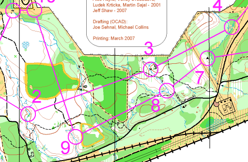
#3) The route was clear and the trick was finding the path to get through the green. I attacked from the trail/stream intersection 100m away, up over the spur and off the trail.
#4) I chose a sequence of "handrails" as my route. I have learned the value of handrails from the masters and always look for these reliable linear features. I ran along the fence planning to leave the path and follow east side of the stream until I saw the marsh. My plan was ok but I thrashed around in the thick stuff and wasted too much time. In retrospect, I should have left the path earlier and run down the spur to the stream.
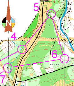
#5) Easy, but a good exercise in finding an attack point. I knew the trail would be hard to find so I used the power line poles and the clearing north of the control to determine when to head into the woods. Of course the contours are the most reliable and I quickly found the reentrant. I also planned my routes to 12 and 13 while running on the road.
#6) A beautiful trail along the river. The trick is leaving the path at the correct place. I decided to attack from the north end of earth bank. Had I known how open the woods were and properly read how significant the "backstop" (the e/w hill) was, I would have left the trail earlier and blasted due south.
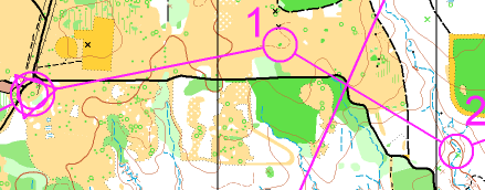
#7) Right or wrong, I chose the road (rather than the windy path) to avoid the green just east of the control.
See the graphic two above here for these next few legs.
#8) Straight and I decided to attack from the trail junction to be safe.
#9) The road is the fastest but, if you're out here to enjoy the beautiful woods, I'm sure the trails are a vastly superior route.
#10) I vascillated quite a few times (during my advance planning) deciding whether to go left or right to 10. The big black trails to the left look seductive but I went right hoping to squeeze along the fence. It turned out to be fast and foolproof.
#11) Offset control had us in the beautiful sun for a stint.
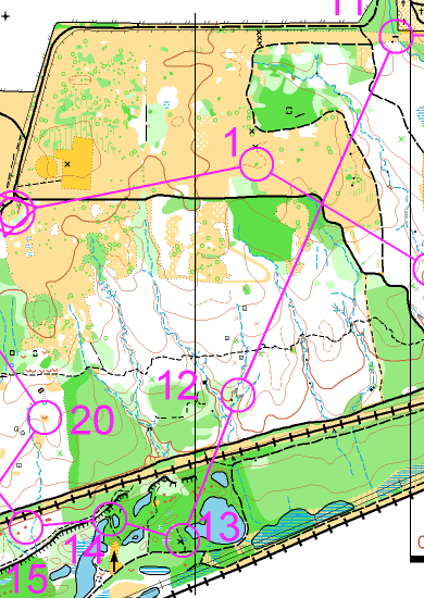
#12) This was my favorite for a lot of reasons but mostly because of the beautiful open woods in the later half of the leg. There are also few route choices but they all start with the path south and a hop to the other path from the bend in the first. The question now is whether to take trails all of the way and use the stream as the handrail south into the control or to take it "overland." I chocse the later because I love open woods running and also hoped it would be faster. I stayed mostly on the purple line by heading across the big field to the road and slid down the clearing between the two green patches. Then it's just SSW across the first stream and south along the second stream.
#13) I heard that at least one person headed straight through the green, but not me.
#14) Also had too much green along the direct route so I decided that the firing range arrow was trying to tell me something.
#15) Another beautiful vista to enjoy along the top of the cliff. Hopefully you didn't get fooled by the unmapped stream 50m early.
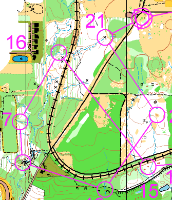
#16) Physically demanding (for me) but didn't present a problem as I took the paths and trails most of the way and then left the tracks at the top of the wide spur.
#17) My plan is always to avoid unnecessary green so I wanted to find the path behind the control and let the contours guide me in. It was a good plan but finding the path presented some difficulty.
#18) "Signature" control of the course. Not the waterfall from which the preserve's name is derived, but beautiful nonetheless.
#19) Finding the path down from the tracks was one trick and the other was not getting fooled by another stream 30m west of the correct one.
#20) The idyllic open woods were reinvigorating after the climb back up. I liked this control because the area was well mapped and if you attack from the fenced areas you can find the feature fairly easily.
#21) I should have run the path the whole way but I foolishy tried the clearing through the green and never found the small path heading NW out of it. Had I been thinking clearly, I would have attacked into the woods from the distinct tree but I just limped in with a prayer that I'd stumble across it. Fortunately, the stream was there to guide me in.
Green Course
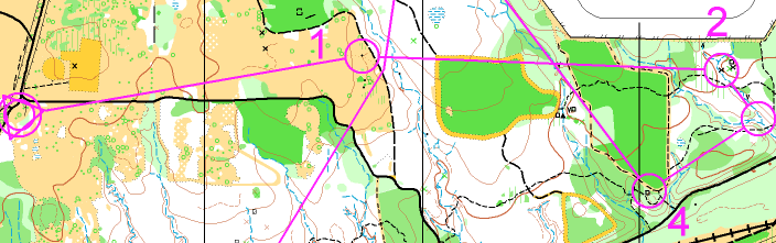
I finally got my hands on a green course map. It looks like most the legs were the same as on red. There were a few unique legs.
#1) Now there's a run for you. I hope you at least had your leg #2 route choice made by the time that you left the trail. I'm guessing the safest route is to head NE from the big trail bend and "bounce off" the thicket south of the control as your attack point.
#2) Nice early route choice. After you ran along the linear clearing north of the green blotch, did you go left along the fence or right to the trails? I'm guessing that going left is faster if you can determine where to leave the fence and head down the stream. Right is safer (and maybe more fun) because you don't have to "fight" to get to the fence. Although the attack from the trail/stream junction or the top of the spur is not difficult, it looks like one could lose some time if you are not careful to leave the trail at the right time and on the right heading.
#3) Looks like an offset control and that going right and down the spur avoids some green spots.
#4) Was this more difficult than it looks? I heard (from a red runner) that he had difficulty finding that trail on his #9.
Nice, but physically tough green course overall, huh?
I found these to be great courses for a lot of reasons. I liked the long distance, I thought the handrails and attack points were well considered and it had a good set of route choice legs (the hallmark of a classic course). Well done Jeff. We look forward to your future courses.
We are all out there to enjoy the sport for our own reasons. My perspective and opinions are of one who is trying to become a technically sound and fast orienteer. Thanks for taking the time to read this. Remember that I know a little, aspire to learn a lot but might forever remain the...
- O-Dilettante
|