|
Another beautiful day for orienteering at great meet run by Valentina, Lenny & Greg Shatskin. This was the second meet they ran this year and I'm sure I speak for the whole club in thanking them for their efforts and success.
On the green course, Viktor Nikolenko ran to the best time but barely nosed-out Sverre Melbye. Jeff Shaw rounded-out the top three.
On the red course Maricel Olaru blazed to another impressive victory. Jim Gordon found his groove to place a solid second.
The previously unknown (around here) Scott Brackebusch and his great run brought in third. Well done all.
Here are the results:
Green Results and Splits...
Green Extended Splits...
Red Results and Splits...
Red Extended Splits...
This terrain is obviously very different from what we experienced at Palos and it exercised some different skills. I found that (although contours are still invaluable) recognizing foliage boundaries was the key to easy navigation. It was certainly easier to move fast and most of this was a "runner's course." Another unexpected factor was "how rough is the rough?" The fields marked "rough open, slow undergrowth" varied widely in how fast you could move across them based on grass density and lot of little saplings. I learned quickly to optimize my time on the deer trails.
I found these courses to be very fine in a number of ways. I think that the best aspect was the presence of so many route choices. Lenny obviously spent a lot of time planning these and it showed in the quality of the navigation exercise. This writeup will discuss the legs and enumerate some of route choices. My perspective is from one who is trying to go fast and certainly some folks have different goals and will navigate differently. This route analysis will discuss the red course because many of the legs were shared by both red and green.
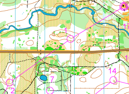
#1) I thought the "creek" would be more like a river (especially after all the rain). I chose to cross at the bridge and run across the rough open. Argh!! The undergrowth was accurately mapped. When leaving the field I determined where I'd enter the woods by "checking off" on the thicket and/or distinctive trees. This allowed me to move on a rough compass bearing to the slope and ditch. Certainly those who arrived here with wet feet (by taking the direct route though the creek) chose the faster route.
#2) After beating a hasty exit to the road I looked at my map while running and planned the rest of my route. There are two main choices (the front door or the back). Either run across the field toward the control and move through the woods or run the trails around to the back. Which did you pick? I like them both but took the trails to avoid the rough and give myself some time to advance plan my routes on upcoming legs. The woods have some "alcove-like" clearings to help you determine where you are entering them.
#3) After getting to the field it seemd like I could go straight and deal with some green or motor along the path and attack from the thickets. Even though the path was bad, I think it is the fastest. This control was placed well to force you to read the contours.
#4) I chose the route through the clearings a little right of center. This field was a very tough slog and I would like to hear how the little trail to the right went for anyone who found it. This control is a perfect example of why you must read the control description and make sure you look for the feature and not the bag.
#5) If you can see it while running, I think the best choice is the trail that takes you almost straight through the woods and turns 100m from the control.
#6) Route choice. There are viable trail options to the left and way right? Right is longer but the left has more slow, off-trail running. I went left. Which did you take? A well-planned leg to be sure.
#7) Now the course becomes more wooded. Although I considered taking the trail most of the way, I didn't think my pace counting would be accurate enough to determine when to leave the trail and cut into the woods? I decided to turn right and attack from the field to the south. I used the reentrant to know where I was entering the woods.
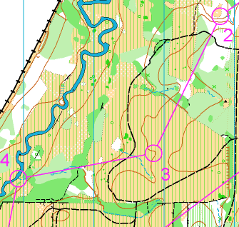
#8) While out there, I saw only one option. That was to take the trail to the right around the big, green blotch. While running by, I took the opportunity to scope-out my attack to control 13 to save some hunting through the bushes later. I do now notice that heading right toward control 13 and then finding the big trail south to the 8 also looks like a good choice.
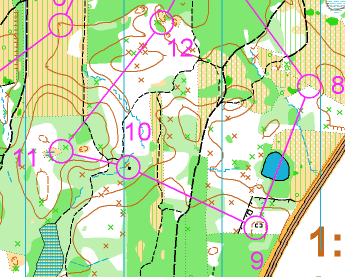
#9) I think that left of the pond provides the best attack point at the forest boundary. The green and the fence provide the backstop.
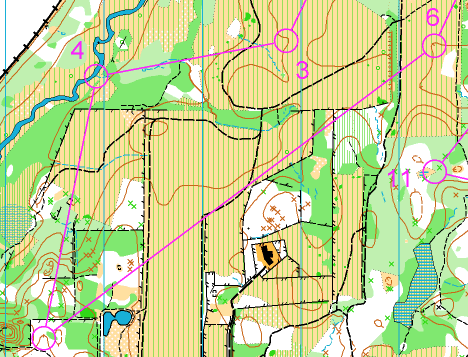
#10) This small stretch of medium green looked ok so plowing straight through it was probably better than hooking around it to the right. Either way, this was a tough attack but there are subtle trail bends and distinctive forest boundaries to determine where I was entering the woods. This planning was almost unnecessary because this thing was huge and nearly visible from the path. After punching, I took a few seconds to figure out what it was (an incinerator) and then a few more to wonder why and how it got out here. There are such curious things deep in the woods.
#11) I liked locating the first depression/clearing and attacking west from it.
#12) Should I try my luck or play it safe? I studied this earlier in the race and determined the straight route looked ok but it's 500m of subtle contours, rootstocks and the clearing is hidden behind a thicket. I'm sure many folks opted for this route and used a compass bearing and/or foliage density. I took the trails to the right. Though longer, it was fast and almost foolproof because I had seen the first clearing from the trail while running to 8.
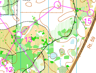
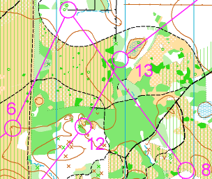
#13) Hopefully you quickly found the mapped thickets and attacked from the closest point. Watch-out for the unmapped fence! Ouch!
#14) I had planned to take the handrail but startled (and was startled by) a big herd of deer and just missed it. Somehow I sensed I had passed it and turned right and quickly found it. I figured I'd hit the N/S earthbank as my backstop if I didn't.
#15) Mini-route choice north or south of the thicket. I chose south so I could take the woods boundary in as my handrail.
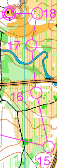
#16) I knew it was important to check off on the woods and thickets to get to the area near the distinctive tree. I had some difficulty here but eventually realized what the control description meant by "distinctive tree."
#17) Left is a long option, right seemed better, but I should have gone straight... SPLASH!!
Just some miscellaneous thoughts on a great course.
- The O-Dilletant
|