|
Meet Director: Fred Hess
Course Setter: Clark Maxfield
Schedule:
| 9:30 a.m. |
Beginners' Clinic |
| 10 a.m. |
Registration and Start |
| 11 a.m. |
Mass start for Green and Red courses |
| 12 p.m. |
Registration closes |
| 2 p.m. |
Courses close |
(Maximum time on course: 3 hours)
Cost: (per individual or team)
| CAOC members |
$5 |
| non-members |
$8 |
| additional maps |
$2 |
| rental compass |
$1 |
| Get
an O-Card |
(We suggest a maximum of four people per group.)
|  |
 |
Details:
This year's romp on the Country Lane Woods map will take
place on May 15 with 75-minute and 120-minute Score-O events to
be offered advanced runners, in addition to standard courses
for the
White, Yellow and Orange competitors.
There will be a Mass Start at 11 a.m. for both the Green
and Red versions of
the Score-O. However, those that cannot make it to the mass start,
are
welcome to start individually at any time between 10 a.m.
and noon.
With the Revenge of the Goat
long-course orienteering event to be offered the following
weekend on the Willow Springs and Palos North maps, this Score
event will
be an ideal opportunity to develop navigational and physical
abilities necessary to complete the Goat.
A score orienteering event differs from a standard run-the-numbers
event in that competitors are free to select both their route AND
the control they next wish to attempt to find. Each control will
have a point value: the higher-point controls will be more difficult
or more distant.
Usually the best strategy on a score event is to
head for the highest point controls early in the competition,
and then design your own route back to the finish, monitoring your
remaining time carefully. A severe penalty is assessed for coming
in after the alotted time period has expired, so make sure you
bring
a watch.
The District has done extensive cutting and burning of buckthorn,
underbrush and nonnative plant species in parts of this forest
preserve, so running and hiking should be much more open and friendly
than you may remember from previous years on this map. But the
downside is that the map may no longer show clearings, trails and
vegetation accurately in all areas.
Public Transportation:
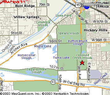
Take Pace bus #381 from the 95th Street Terminal (in the middle
of the Dan Ryan Expressway) on the Red elevated line at either
8:30 a.m. or 9:30 a.m. Get off bus at end of line at
Moraine Valley Community College and walk west on 107th Street
for less
than
a mile. Turn right (north) on Kean Avenue and then left into
the Forest Preserve.
Driving:
From the north, take LaGrange Road-South from Stevenson Expressway
(I-55). Turn left (east) at 107th Street, and then left again
on Kean Avenue, and then a third left into the forest preserve.
|

