|
Meet Director: Joe Sackett / Charlie Shahbazian
Course Setters: Lenny & Greg Shatskin
Schedule:
| 9:30 a.m. |
Beginners' Clinic |
| 10 a.m. |
Registration and Starts begin |
| 12 p.m. |
Registration closes |
| 2 p.m. |
Courses close |
(Maximum time on course: 3 hours)
Cost: (per individual or team)
| CAOC members |
$5 |
| non-members |
$8 |
| additional maps |
$2 |
| rental compass |
$1 |
| Get
an O-Card |
(We suggest a maximum of four people per group.)
|  |
 |
Details:
The location is still in question. Check back here for more details
later.
Located on the ridge formed by the lakeshore of the pre-glacial Lake Chicago
before Niagara Falls was formed, the Chicago and Illinois Rivers carried
most of the water from the Great Lakes. Swallow Cliff Forest is on some of
the steepest terrain in our area.
A high east-west ridge intercut by steep-sided
ravines and reentrants runs the length of this map, and allows some interesting
courses to be set. Should you
run up and over the big ridge in front of you, or follow the meandering trail
around the reasonably flat valley? And how accurately can you follow your compass
once you get to the top of the broad, featureless plateau...? Can you dependably
continue 300 meters and hit the small side reentrant where the control is located?
While
White, Yellow and Orange courses will be located in the trail
network to the east and north of the start, the Green and Red advanced
courses will
cross
the road and plunge into the extensive Cap Saucers Holding map to the west.
Directions:
Public Transportation: Take Pace bus #381 from
the 95th Street Terminal (in the middle of the Dan Ryan Expressway)
on the Red elevated line at 8:30 a.m. Get off bus at end of line
at Moraine Valley Community College and walk west on 107th Street
one mile to turn south on Hwy 45 (96th Avenue) which takes you
across the Sag Channel. Turn west again on Calumet Sag Road (Hwy
83) for a mile, then turn left on 104th Avenue and up the hill
half a mile to Registration. On the return, ask someone in the
parking lot to drop you at MVCC where return buses depart every
30 minutes all afternoon.
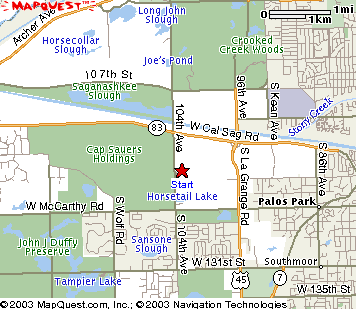
Driving: From the north, take LaGrange Road-South
from Stevenson Expressway (I-55). Go South on LaGrange Road until
Hwy 83 / West Cal-Sag road, Turn right (west) onto Hwy 83. Turn
south on 104th Avenue (next left)
and then follow orienteering signs into the first parking area
and follow the trail south to registration. This is the overflow
lot; the lot near the registration shelter at the top of the hill
has limited capacity and will be full by 10 a.m. Do not
park on 104th Avenue!! The Club will be cited by Forest Preserve police
if congestion or dangerous parking occurs. Please cooperate.
|